Easy-to-use cloud solution for quickly and accurately calculating the flatness of concrete floors required for robotic warehouses.
100 credits (with a subscription)
200 credits (without a subscription)
Version 1.7
Free Trial available!


See how RoboFlat streamlines concrete floor flatness and levelness analysis.

Learn more about the RoboFlat workflow, including automatically cleaning point cloud data before delivering floor flatness and levelness results.
Convenient Anytime, Anywhere Access
Scanned floor data can be uploaded from any browser.
Large Scale
RoboFlat can process the point cloud of the entire floor while delivering the high performance and scalability that you need to ensure the floor meets exacting specifications.
Customizable and Flexible
RoboFlat is customizable to suit the specific needs of your building, and flexible enough to handle free movement floors for robotic systems.
Saves Time
With this innovative technology, calculations could be fed directly into concrete leveling machines to facilitate real-time remediation.
Device Agnostic
This agnostic solution is compatible with all scanner manufacturers, allowing you to use the scanner that you prefer to get the job done.
Required Inputs
Expected Outputs
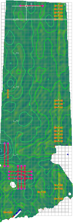
- Excel files that include full test results, failure totals, and failure threshold deviations
- DXF file with full test results
- Related PNGs to support heat / contour maps
- Customizable report for stakeholders

RoboFlat automatically calculates concrete floor flatness and levelness, identifying areas that need remediation. Designed for use in robotic warehouses and distribution centers that need critical-tolerance concrete floors, RoboFlat helps ensure that robotic warehouses are built to specification.